Huron River Renaissance: Ann Arbor Rediscovers Its River
When my husband and I were first married in the mid-1960s, we often wandered down to Argo Park, which was only two blocks away from our home on Pontiac Tr. We'd go into what was then Wirth's Canoe Livery, in a building which the family also lived in, and put a dime in one of their nickelodeons or sit on the screen porch and enjoy the view of the Huron River.
We were always the only ones there. After we had our first child, we would take him down to the playground at Longshore Park across from Argo, and again we were always the only ones there.

Saline's Plymouth Rock
Saline's Plymouth Rock
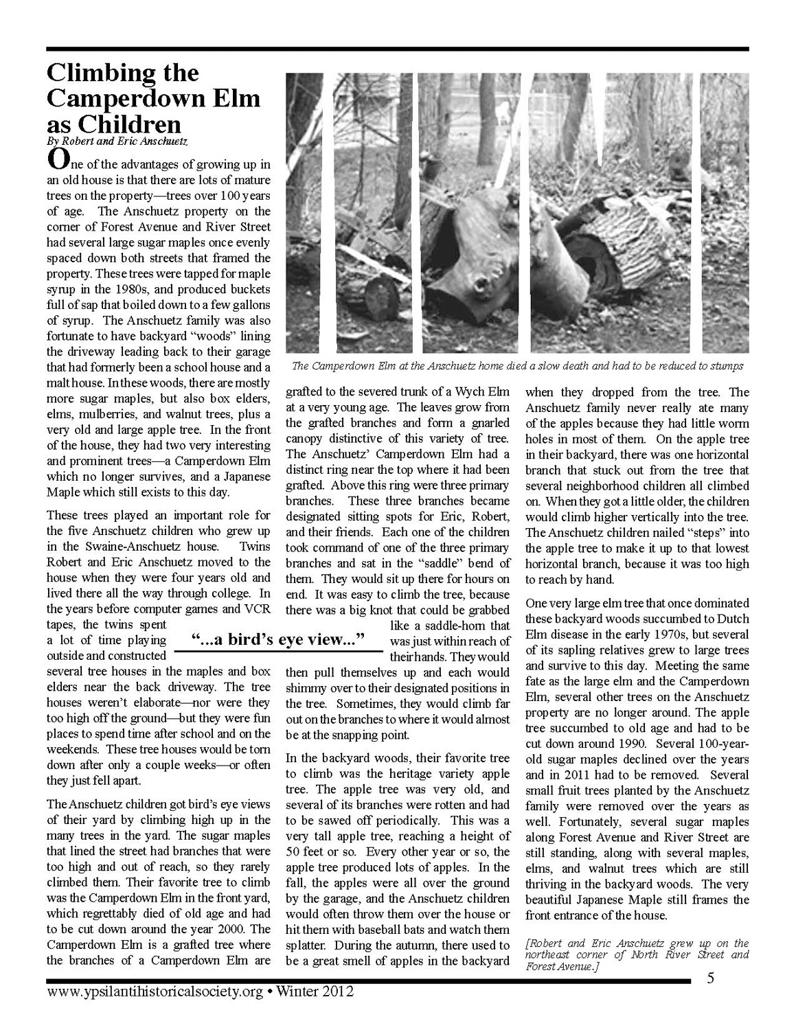
A playful dog rediscovers a long-lost salt spring.
Saline's name and identity are tied up with salt, yet the actual salt springs that once bubbled up along the Saline River south of town hand't been seen since the area was drained for farming in the nineteenth century. But last year, Jim Peters accidentally discovered a slat spring that is still active!
Peters and his dog Bonnie, a gentle but energetic pit bull terrier, were hiking on undeveloped city land near Saline's wastewater treatment plant. Bonnie pulled Peters toward a muddy puddle to get a drink. "As she got close, she sank in up to her chest in muck. Before I could pull her out, she had backed herself, out," he recalls.
Peters washed the grayish mud off Bonnie in the nearby Saline River, then went back to take a closer look at the puddle. “I noticed very few plant varieties growing nearby and that the mud was covered with deer tracks.” That’s when Peters, then a city councilmember, had his “aha” moment: Why were the deer drinking there when they could have used the river? And why was the puddle in a clearing with no trees and substantially less vegetation than anywhere else nearby?
Peters collected some of the watery muck in a plastic bottle he found and took it to the city lab to be tested. “When the report came back that it was as salty as sea water, I was like a kid at Christmas,” recalls Peters. He double-checked these findings using a cleaner bottle and another lab. Again the same results came back.
As soon as his suspicion was confirmed, Peters contacted Saline historian Bob Lane. The two men began working together, Peters researching the salt springs’ prehistory and Lane putting the more recent Saline history in context.
Peters research revealed that Saline’s salt springs are part of an ancient sea bed formed about 600 million years ago, which extended from present-day New Jersey to Wisconsin. (Detroit’s salt mines are part of the same system.) When the Ice Age was over, about 12,000 years ago, animals and people began moving into this area. Prehistoric animals came to drink at the salt springs. Remains of mastodons and mammoths have been found nearby.
Native Americans followed, drawn by the good hunting and also because they too liked the salt. Their remains have also been found. According to the 1881 History of Washtenaw County, Michigan, “Early seekers for relics did not hesitate to open shallow graves and the ground was strewn with the bones of departed warriors.” Lane has identified the location of two Indian burial mounds near the salt springs. One has been leveled for the Crestwood subdivision--people remember finding bones and relics at the time it was being built in the 1960s. A hill west of the DNR Fisheries is believed to be the other. The most recent Indian residents, the Potawatomi, who came to this area in the sixteenth century, used six paths, still there, that converge at the springs. They were known to trade salt with neighboring tribes.
Frend explorers gave the Saline River its name in the 1600s. The first European visitors also appreciated the salt springs. Trappers used the salt to preserve beaver pelts, which were in great demand in Europe for hats. The springs were first pinpointed on a map in 1819 by surveyor Joseph Francis in section 12 of Saline Township.
In 1826, the first permanent settler in Saline Township, Leonard Miller, built his home near the salt springs. Others built nearby. In 1829, F. A. Dewey, a pioneer travelling to Tecumseh, wrote of taking the United States Military Road “west through the Saline River near the salt springs.” This road, the first across the state, ran from Detroit to Chicago following an old Indian trail; it's now Michigan Avenue. In 1832, Orange Risdon, who'd surveyed the road, laid out the town of Saline on high ground north of the salt springs.
The 1881 County History told of an attempt by a group of local men to manufacture salt in 1863. “A building was erected, a derrick put in place, and boring commenced. After three unsuccessful attempts to sink a well, the project was abandoned. There has always existed a doubt in the minds of many whether the contractor engaged to sink the well acted in good faith. The charge is boldly made that he was bought off by rival interests,” they reported.
Evidence of this failed endeavor was found in 1944, when a farmer named Harry Finch was plowing for corn and felt his plow sink down. Investigating, the site he found evidence of the former salt wells. The late Ray Alber, who farmed on land marked as part of the salt springs, once told Lane that he remembered that he and other farmers used to pick up salt clumps that they’d give to their animals.
Lane worked out the wells' location on the west side of Macon Road and has shown it to people as part of historic tours. and has shown it to people as part of historic tours. He has also, with the land owner’s permission, gone over the ground with a metal detector but found nothing left of the would-be salt works.
The 1863 mining attempt is the last reference to active salt springs. When the County History was written eighteen years later, the authors felt the need to offer proof that the salt springs had even existed: “That salt has been made here in years gone by cannot be doubted. Iron kettles have been found which were once doubtless used for this purpose."
So Peters’ delight at his find is easy to understand. The spring presumably escaped discovery for so long because it's in an overgrown area that people rarely visit. Even if another dog had dived in as Bonnie did, only someone well versed in Saline history would have realized what the muddy puddle might be.
Last October, Peters sponsored a bill to create “Salt Spring Park” on the land where he found the active spring. It passed unanimously. “A forgotten parcel of city-owned land in the Saline River valley will now be available for all to enjoy as a unique park dedicated to our local heritage," explains Peters. “It will allow us to provide proper stewardship of our salt springs, enjoy nature and reconnect with Saline’s distant past.” Lane is equally enthusiastic, explaining “There is nothing now in town that explains why we are called ‘Saline.’”
Peters' council term ended last year, but he's continuing to work on the project as a member of the parks commission. His vision is to leave the site as natural as possible but to improve the trail and build an observation deck with signage at the spring, so people won’t get as muddy as Bonnie did. He would like someday to see the spring connected by a walking trail to Curtiss and Millpond parks-- he says that could be “a beautiful, safe, free from car traffic path, much of which is along the river.” He knows all this will take money, which he hopes can be provided with grants. The local Eagle Scouts have already volunteered to clear the overgrown path.
Peters worries that the muddy puddle would underwhelm some people. He compares the spring to Plymouth Rock: “It’s just a brown rock to some – but it’s what it stands for, not what it looks like.” But so far, the reaction fromt he public has been very positive. "People find it fascinating," he reports.


Pulling the Plug on Mill Creek
The recent decision to remove Dexter's Mill Creek Dam promises an ecological and recreational payoff.
The Dexter Village Council voted in mid-February to accept the recommendation of the Mill Creek Dam Task Force to remove the 175-year-old dam. Still unresolved, however, are two large questions: who owns the dam and who will ultimately pay for its removal.
But even with money at issue and no official timetable established, one thing is certain: the removal of the dam, which has not been used as a power source for more than eighty years, promises a flood of ecological and recreational advantages. Not only will the creek run faster and cleaner without the dam, thus allowing for a healthier and more varied aquatic life, the water will return to its original narrower channel, leaving more dry land at its edge for nature study and recreation.
The first dam on the site, just west of downtown, was built in 1825 .by village founder Samuel Dexter. Dexter had selected the site for his town a year earlier specifically because it was on a creek, just off the Huron River, that could be dammed for power. He harnessed that power to build a sawmill on the west side of the stream, about where Mill Creek Sporting Goods is now. Next he built a gristmill on the opposite side, where the village offices and fire department now stand. The sawmill business did not last long, but the gristmill continued to operate for nearly a century, run by a variety of owners before it closed in 1917.
In 1920 Henry Ford, who was buying up mills all over southeast Michigan to encourage the development of small village industries, bought the gristmill and water rights. He rebuilt the Mill Creek Dam and began work on the mill building, but died before it could be completed. The village-industry project died with Ford, and in 1957 Ford Motor Company sold the old mill and the land to the village.
In 1995 the Fisheries Division of the Michigan Department of Natural Resources issued a report, the Huron River Assessment, that recommended the removal of retired hydroelectric dams. The DNR's arguments for cleaner water and recreational opportunities intrigued the Dexter Village Council. The timing was also right: the replacement of the bridge over the dam is on the Washtenaw County Road Commission's project list, and if the dam is removed, the bridge will span less water and be cheaper to replace.
Part of the delay in removing the dam until now has been determining who owns what part of it. According to John Coy, village president and chair of the task force, the research so far indicates that the village owns the land on the east side of the dam, the county owns the land on the west, and the Ford Motor Company owns the spillway. However, he says, "who owns and who pays" for removal may be two different issues. Since the village can not afford such a big project, it will be applying for grants from sympathetic groups such as fisheries organizations, parks commissions, and state and federal environmental groups.
Huron-Clinton Metroparks officials have recently announced plans that should add to the attractiveness of the project. They plan to build a five-mile bike and hiking trail that would run all the way from Mill Creek to Huron Mills Metropark.
—Grace Shackman
Gunther Gardens
A motionless windmill marked the gardens of a renowned landscape architect
For many years, a huge deserted windmill north of Saline puzzled those who passed by it on Ann Arbor-Saline Road. Neighborhood children said it was haunted.
The windmill never ground grain. It was actually built as a tearoom for the Gunther Gardens, a formal garden and nursery that operated from 1927 to 1939. Developed by Edmund Gunther, a brilliant but eccentric landscape architect, and his hardworking wife, Elsie, the gardens covered 160 acres.
The "windmill" was an inspired piece of recycling: it was built around the remains of an old silo. The tearoom's sixty-five-seat dining room, which occupied an addition around the base, was furnished with Arts-and-Crafts-style handmade furniture and wrought iron lantern-style lamps. The silo itself contained the kitchen, bathrooms, and a stairway that led to a balcony. From the balcony, visitors could see the gardens spread out below them and the vanes of the windmill rising above them.
"It didn't rotate; it was just for looks," explains the Gunthers' son, also named Edmund.
Why did Gunther build it?
"When you live in Europe, you have different ideas," says Gunther's daughter, Viola Hall.
The tearoom was not open to the public but was used for special events. Groups such as garden clubs or university organizations would book special events at the tearoom. They'd come for a catered meal, a talk by Gunther, and a tour of the gardens.
Because of the windmill, many assumed that Gunther was from the Netherlands, but actually he and Elsie were born in Germany. He studied landscaping in Zurich before immigrating to the United States and attending theology school in Rochester, New York, to become a Congregational minister.
"During World War I, he couldn't preach," says Hall. "They thought he was a German spy. So he moved lo East Lansing and got a degree in the [MSU] landscape program." Gunther worked at a botanical station in Florida and then moved to Ann Arbor to work as a landscape architect.
In 1926 the Gunthers bought a dilapidated farm outside Saline and developed their gardens. They filled in a swamp with loads of dirt. Elsie Gunther, who had learned gardening from her father, supervised the crews and selected the plants. Edmund was the dreamer. "His head was always up in the clouds," recalled Elsie in a 1976 interview.
Edmund Gunther's specialty was wild gardens, so his showpiece featured plants native to the area. Artesian wells on the property fed a kidney-shaped pool with a waterfall in front of the teahouse, and an artificial lake behind Gunther's office. He created rock gardens and sunken gardens, to give potential buyers ideas of what could be done with the plants he specialized in. He increased the variety in his designs by changing the temperatures in his greenhouses, forcing plants to bloom early or holding them back. He went to Indiana to collect dogwoods, to the Carolinas for rhododendrons, and to northern Michigan for cedars.
Gunther's unusual designs brought him awards and wealthy customers. He landscaped factory sites, Hillsdale College, a park in Adrian, and residences in most of southeast Michigan's affluent suburbs. In 1927, he won first prize at the North American Garden Show with a wild garden exhibit. He won again the next year, this time with an octagonal garden. He created a ten-acre flowering meadow for Detroit industrialist William Knudson, and a lavish garden to set off a display of new Chryslers. He also worked for Henry Ford—once designing a rose garden for Ford's wife, Clara—and Ford visited periodically to talk about soybean farming.
Gunther Gardens was a critical success, but not a financial one. During the Great Depression, landscape gardening was a luxury few could afford. The Gunthers tried every way they could to keep the business afloat, including renting out some of the land to farmers. The younger Edmund Gunther recalls that at the end, his dad was working with a religious group in Cleveland to re-create the Hanging Gardens of Babylon, trying to develop a synthetic rubber out of milkweed (in anticipation of World War II), and building dormitories behind his house in hopes of offering classes on landscaping.
But the Gunthers couldn't make the payments on their land contract, and their endeavor ended inelegantly. The sheriff's deputy evicted them, throwing all their possessions out on the road.
The Gunthers were devastated. Their marriage ended, and they both went through hard times for a while. Edmund remarried and returned to the ministry at a small church in Gibraltar, south of Detroit. Elsie moved back to Ann Arbor and ran several boardinghouses, with the financial help of Clara Ford. She showed her gratitude by baking Clara coffee cakes.
After the Gunthers left, the gardens became overgrown, but the windmill remained standing until 1965, when it fell over in a storm. About five years ago, Ann Arbor's Guenther Building Company—no relation to the Gunther family—bought the land and developed it into a subdivision. It was also named Gunther Gardens in honor of the family. In a touch that Edmund Gunther himself would surely have appreciated, the company built a faux-historic covered bridge at the entrance.
—Grace Shackman